This page is no longer current and is provided for archival and research purposes.
Geographic profiles
There are many ways to subdivide ░─├┼╙└└√ geographically. The province can be partitioned on administrative or ecological boundaries, watershed or electoral districts, ownerships or even forest or wildlife management units.
This version of the Forest Resources of ░─├┼╙└└√ summarizes several commonly referenced subdivisions, focusing on landcover class area rather than detailed FRI summaries. The AOU will be referenced where applicable to highlight area of managed forest within many of these zones.
Rowe's forest regions
J. Stan Rowe was a geo-ecologist that worked for Forestry Canada and the University of Saskatchewan. In 1959 he wrote "Forest Regions of Canada" which is perhaps one of the most commonly used systems to describe Canadian forests. The map layers used in this version of "The Forest Resources of ░─├┼╙└└√" varies slightly to those used previously, due to better mapping standards, and is based on the 1972 version of Rowe's map.
Each forest region is characterized by its climate, forest ecosystems and wildlife species. North-south gradients in temperature and east-west gradients in precipitation largely determine the extent of these forest regions. Most of ░─├┼╙└└√тАЩs population lives within the Great Lakes and Deciduous forest regions. Since RoweтАЩs did not define forest regions into the great lakes, some area has been omitted from the summaries, primarily great lakes water. The AOU is almost exclusively on the boreal and great lakes forest regions.
Total area by land class and forest region (hectares)
| Land class | Hudson Bay Lowlands | Boreal Forest | Great LakesтАУSt. Lawrence Forest | Deciduous Forest | Total |
|---|---|---|---|---|---|
| Water | 1,876,738 | 6,381,062 | 2,411,969 | 29,552 | 10,699,321 |
| Wetland | 7,595,680 | 1,602,817 | 240,368 | 36,285 | 9,475,151 |
| Field/Agriculture | 0 | 64,739 | 3,301,828 | 2,028,417 | 5,394,985 |
| Other | 368,672 | 594,430 | 767,045 | 388,113 | 2,118,259 |
| Treed Wetland | 9,760,624 | 4,008,146 | 1,004,660 | 197,638 | 14,971,067 |
| Forest | 6,309,004 | 37,053,429 | 12,410,324 | 307,231 | 56,079,988 |
| Total Area | 25,910,718 | 49,704,622 | 20,136,193 | 2,987,236 | 98,738,770 |
Total area by forest region within the AOU (hectares)
| Area | Hudson Bay Lowlands | Boreal Forest | Great LakesтАУSt. Lawrence Forest | Deciduous Forest | Total |
|---|---|---|---|---|---|
| Total Area | 25,910,718 | 49,704,622 | 20,136,193 | 2,987,236 | 98,738,770 |
| Total Area within AOU | 599,184 | 30,199,930 | 14,179,894 | 0 | 44,979,007 |
| Crown Forest within AOU | 342,152 | 20,320,726 | 6,309,357 | 0 | 26,972,234 |
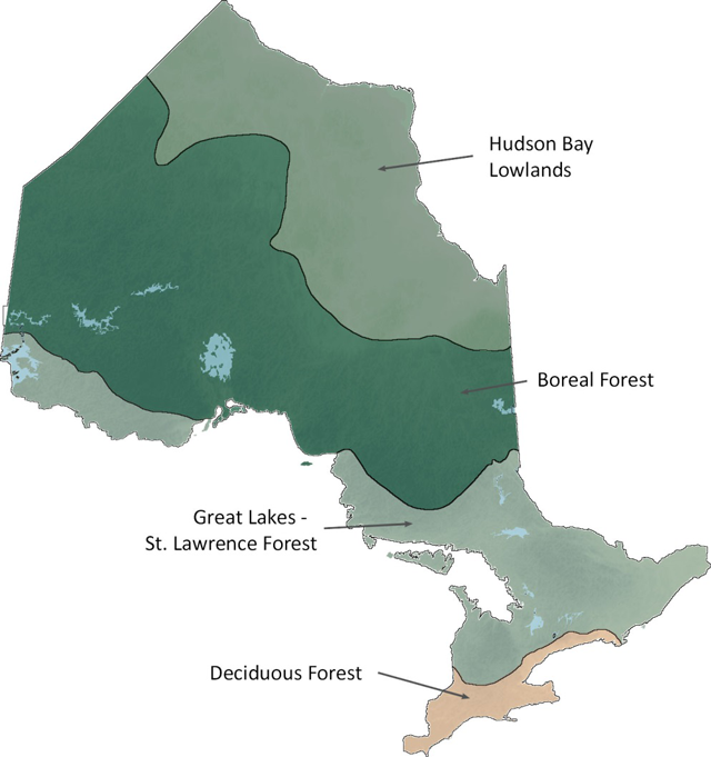
Map of Rowe's forest regions
Area by region

Hudson Bay lowlands forest region
The Hudson Bay Lowlands is the northernmost forest region in ░─├┼╙└└√, and is dominated by bogs and fens, sparse slow growing forest and tundra. Productive forest is generally made up of stunted Tamarack and Black Spruce growing along river banks and other well-drained areas. White Birch, dwarf birch and willow are the common deciduous trees in this forest region.
Total area by land class and ownershipтАУHudson Bay lowlands (hectares)
| Land class | Crown | Parks and protected areas | Other | Total |
|---|---|---|---|---|
| Water | 1,619,983 | 252,661 | 4,094 | 1,876,738 |
| Wetland | 6,618,956 | 958,638 | 18,086 | 7,595,680 |
| Field/Agriculture | 0 | 0 | 0 | 0 |
| Other | 120,207 | 246,619 | 1,846 | 368,672 |
| Treed Wetland | 8,886,344 | 829,125 | 45,154 | 9,760,624 |
| Forest | 5,917,102 | 346,337 | 45,565 | 6,309,004 |
| Total Area | 23,162,592 | 2,633,381 | 114,745 | 25,910,718 |
Boreal forest region
░─├┼╙└└√тАЩs boreal forest is the largest forest region in ░─├┼╙└└√ and Canada and contains two-thirds of ░─├┼╙└└√тАЩs forest. It extends from the northern limits of the Great LakesтАУSt. Lawrence forest to the Hudson Bay Lowlands.
Coniferous (softwood) and mixed-wood forests dominate the Boreal region. The main conifer species are black and White Spruce, Jack Pine, Balsam Fir, Tamarack and eastern White Cedar. The predominant deciduous (Hardwood) species are Poplar and White Birch.
Total area by land class and ownershipтАУboreal forest (hectares)
| Land class | Crown | Parks and protected areas | Other | Total |
|---|---|---|---|---|
| Water | 5,101,278 | 1,144,127 | 135,657 | 6,381,062 |
| Wetland | 1,467,074 | 120,944 | 14,800 | 1,602,817 |
| Field/Agriculture | 3,792 | 42 | 60,905 | 64,739 |
| Other | 401,627 | 115,543 | 77,260 | 594,430 |
| Treed Wetland | 3,605,735 | 324,858 | 77,553 | 4,008,146 |
| Forest | 31,435,390 | 3,988,659 | 1,629,380 | 37,053,429 |
| Total Area | 42,014,895 | 5,694,173 | 1,995,555 | 49,704,622 |
Great lakesтАУSt. Lawrence forest region
The Great LakesтАУSt. Lawrence forest is the second largest forest region in ░─├┼╙└└√. This forest extends along the St. Lawrence River across central ░─├┼╙└└√ to Lake Huron and west of Lake Superior along the border with Minnesota.
The Great LakesтАУSt. Lawrence forest is dominated by Hardwood forests, featuring species such as maple, oak, Yellow Birch, white and Red Pine. Coniferous trees such as White Pine, Red Pine, Hemlock and White Cedar, commonly mix with deciduous broad-leaved species, such as Yellow Birch, sugar and Red Maples, basswood and Red Oak.
Total area by land class and ownershipтАУgreat lakes forest (hectares)
| Land class | Crown | Parks and protected areas | Other | Total |
|---|---|---|---|---|
| Water | 1,642,259 | 420,732 | 348,977 | 2,411,969 |
| Wetland | 49,593 | 19,332 | 171,444 | 240,368 |
| Field/Agriculture | 22,799 | 5,991 | 3,273,038 | 3,301,828 |
| Other | 158,851 | 80,937 | 527,257 | 767,045 |
| Treed Wetland | 191,470 | 46,350 | 766,840 | 1,004,660 |
| Forest | 6,764,873 | 1,503,264 | 4,142,187 | 12,410,324 |
| Total Area | 8,829,845 | 2,076,606 | 9,229,743 | 20,136,193 |
Deciduous forest region
The deciduous forest is the southernmost region in ░─├┼╙└└√, dominated by agriculture and urban areas. This region has largely been cleared with scattered woodlots remaining on sites too poor for agriculture. This forest generally has the greatest diversity of tree species, while at the same time having the lowest proportion of forest.
It has most of the tree and shrubs species found in the Great LakesтАУSt. Lawrence forest, and also contains black walnut, butternut, tulip, magnolia, black gum, many types of oaks, hickories, sassafras and red bud &mdAsh; species commonly found in Ohio, Pennsylvania and the Carolinas in the USA.
Total area by land class and ownershipтАУdeciduous forest (hectares)
| Land class | Crown | Parks and protected areas | Other | Total |
|---|---|---|---|---|
| Water | 1,056 | 379 | 28,117 | 29,552 |
| Wetland | 869 | 1,625 | 33,791 | 36,285 |
| Field/Agriculture | 1,304 | 2,138 | 2,024,975 | 2,028,417 |
| Other | 280 | 680 | 387,153 | 388,113 |
| Treed Wetland | 892 | 2,538 | 194,209 | 197,638 |
| Forest | 1,330 | 4,671 | 301,231 | 307,231 |
| Total Area | 5,730 | 12,031 | 2,969,475 | 2,987,236 |